BOOK
NAVIGATION
Introduction
Earliest Settlement
The
Mansions of Elk Garden
The Great
Awakening
The Stuart Family
Lead, Salt,
& Cattle
Wealth
Leads to Politics
Addendae
Bibliography
Genealogies
Index
|
Garden give mute testimony to this fact.
There are surprisingly few good springs in Elk Garden.
A number of the traditional sites of the fort have no
springs at all.
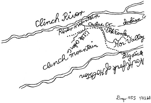
Magnified Portion of the
Smith Map Showing Elk Garden Proper
Daniel Smith was on the committee that ran the line between
North Carolina (Tennessee) and Virginia, and in doing so had a
run in with East Carter’s Valley famous Tory, Major John
Anderson. Smith
drew a map of the larger region about Elk Garden, and it is from
this map that we know the general location of the Elk Garden
Fort. The map was
drawn by the man who built the fort.
He was a professional surveyor.
The map is built to precise scale.
It shows “Elk Garden” to be between the forks of Big
Cedar Creek, or south of the North Fork (current Elk Garden
Creek) and north of the South Fork (current Loop Creek).
There are only two good springs within that zone.
One is partially flooded by the Hendrick’s Mill Pond.
The other is on the southern lip of Thomas Price’s land,
on a tract sold off of
the current Ellenwood / brook estate (see following).
Tradition has it that Fort Elk Garden was ‘near’ the
mansion of Thomas Price, now Ellenwood / brook.
It is south of the creek, and next to the old Indian
trail, now State 80.
Smith went on to fight at King’s Mountain and at Guilford Court
House. At the end of the
war he moved to Sumner County, Tennessee to claim his 3140 acre
land grant that was given to him for his Revolutionary War
service. He built his
estate, which he called ‘Rock Castle’ there.
He became a member of Tennessee’s ...
Continued, Page 6 |