|
On the other hand the lay of the land was a defender’s dream.
The road down the valley just before it reaches town
forded Cedar Branch.
Just
after this passage there is just enough room for the road to
make its passage through a gap between the butt end of Chestnut
Ridge and the steep hill on which Elizabeth Cemetery is perched.
This river continues north to the river, which is too
deep to ford at this point.
On the other side of the river Little Mountain abruptly
rises from the edge of the river.
It comes close to forming a bluff.
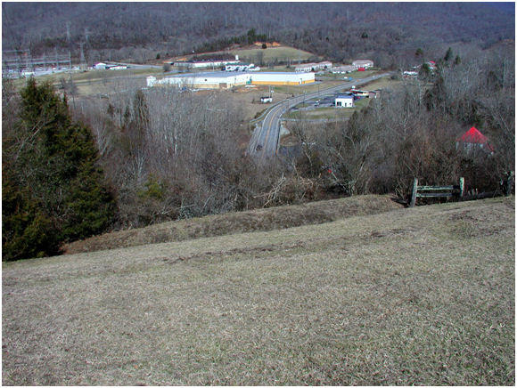
The Saltville
Battlefield – In the Foreground are the Rifle Pits of
the Confederate
Defenders.
The Union Troops Had Come Down the Road in the Center,
and
Were in Broady Bottom in the
Center of the Photograph.
The Bridge Over Cedar Branch is in the Center.
Behind the Electric Substation to the Left Background is
Where the Union Tried to Turn the Confederate Left.
Elizabeth Cemetery is Off Camera to the Left Rear
The Confederates skillfully made use of this choke point, and
dug rifle pits on the hills, and placed cannon on the edge of
Elizabeth Cemetery.
Riflemen were placed on the south
bank of the river where they commanded the river and the flat
bottom between the river and the road.
Riflemen crouched behind tombstones
in the cemetery.
... Continue
to PAGE 40
39

Return to Big Stone Gap Publishing.com
Copyright © 2014 Lawrence J. Fleenor, Jr.
All Rights Reserved
|